New satellite images from the Indian Space Research Organisation (ISRO) reveal the shocking extent of recent flood devastation, showing the town of Dharali completely changed. The powerful floodwaters have reshaped the landscape, with ISRO’s visual evidence painting a stark picture of houses, roads. land now submerged or vastly altered. These current images provide the first clear look at how the region has been hit, highlighting the urgent need for aid as the full impact of the natural disaster becomes painfully clear from space.
Seeing the Damage from Space
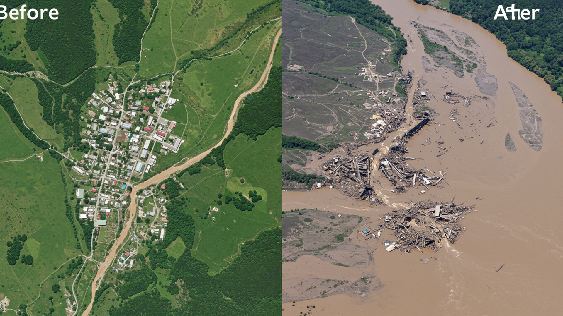
The Indian Space Research Organisation (ISRO) has released new satellite images showing the severe impact of a recent flood in Dharali village, located in Uttarakhand’s Uttarkashi district. These images offer a clear view of how the area has changed after the flood on August 5, 2025. ISRO’s National Remote Sensing Centre (NRSC) carried out a quick review of the damage using very clear satellite images from India’s Cartosat-2S satellites. Such satellite views are vital for understanding the scale of disasters, as they can show large areas from above, guiding rescue and relief teams to places that need help the most.
Before and After: A Clear Difference
The new satellite pictures, taken on August 7, 2025, were compared with older pictures from June 13, 2024. This comparison clearly shows the widespread damage. One major change is a large, fan-shaped area of mud and rocks at Dharali village, where the Kheer Gad stream meets the Bhagirathi River. This area measures about 750 meters by 450 meters and covers roughly 20 hectares. The images also show that the flood greatly changed the shape of the rivers. Stream channels became much wider. the river paths themselves were altered, which are typical signs of a fast-moving flood. Many buildings in the flood-hit area are either partly or completely buried in mud and debris, or they have simply vanished. Some houses that were once next to the Bhagirathi River appear completely flooded, as if they were never there. Roads and a small bridge over the Kheer Gad have also been washed away.
“The comparison analysis of satellite images of 07. 08. 2025 (post-event) and available cloud-free pre-event data (13. 06. 2024) revealed the extent and severity of the destruction,” ISRO stated. “Indications of flash flood, with widened stream channels, altered river morphology and damage to human lives & infrastructure.” “A fan-shaped deposit of sediment & debris at Dharali village (~20ha area, ~750m X ~450m), at the confluence of the Kheer Gad & Bhagirathi River.”
What Happened on the Ground
The satellite images confirm the severe impact felt by people living in Dharali. The catastrophic flood, which was caused by heavy rain, swept away homes, buildings, bridges. roads. The sudden rush of water and mud caused heavy damage to property and led to loss of life. Several buildings in Dharali village are now under thick layers of mud and debris. Local reports suggest that the mud and debris are very thick, possibly 30 to 40 meters deep in some places. This has led to widespread disruption, affecting homes, schools. public services. Parts of the main highway, NH-34, which goes towards Gangotri, were blocked because of the debris. power and phone lines were also cut off in nearby areas.
Helping Those Affected
The satellite images are playing a key role in the ongoing rescue and relief efforts. They help officials find people who are stuck and work to reconnect isolated areas. After the disaster, around 1,300 people were rescued or moved to safer places. Rescue operations continued with the help of helicopters, moving stranded people to safety. While many have been rescued, some people are still missing, including local residents and workers. District officials have confirmed some deaths. efforts continue to account for all missing persons.
Looking Ahead: Planning for Safety
The flood in Dharali brings attention to how easily Himalayan settlements can be hit by disasters. ISRO stated that a scientific study is being done to figure out the exact cause of the flood. While early reports pointed to a cloudburst, some experts believe it might have been a larger geological event, such as a massive collapse of rock and sediment from high in the mountains, due to unstable ground. This event created a huge amount of debris, like more than 140,000 Olympic-sized swimming pools filled with mud and rocks, which rushed down into the village. Experts warn that such sudden changes to river paths can have effects far downstream, changing how fast water flows and making riverbanks unstable for many kilometers. This highlights the need for careful planning when building in such naturally changing areas. The use of satellite data will be crucial for future planning, to help build safer communities and better prepare for natural events. ![]()