


Coastal Tamil Nadu is on high alert as the India Meteorological Department (IMD) warns of stronger winds coming in August. The IMD issued a special gust alert, telling people living along the coast to get ready for rougher weather. This urgent warning means communities from Chennai down to Kanyakumari must prepare for sudden, powerful gusts that could impact daily life and safety. Authorities are closely watching the situation, urging residents to take immediate steps to secure property and stay safe as the wind threat approaches.
Watching the Winds in Coastal Areas
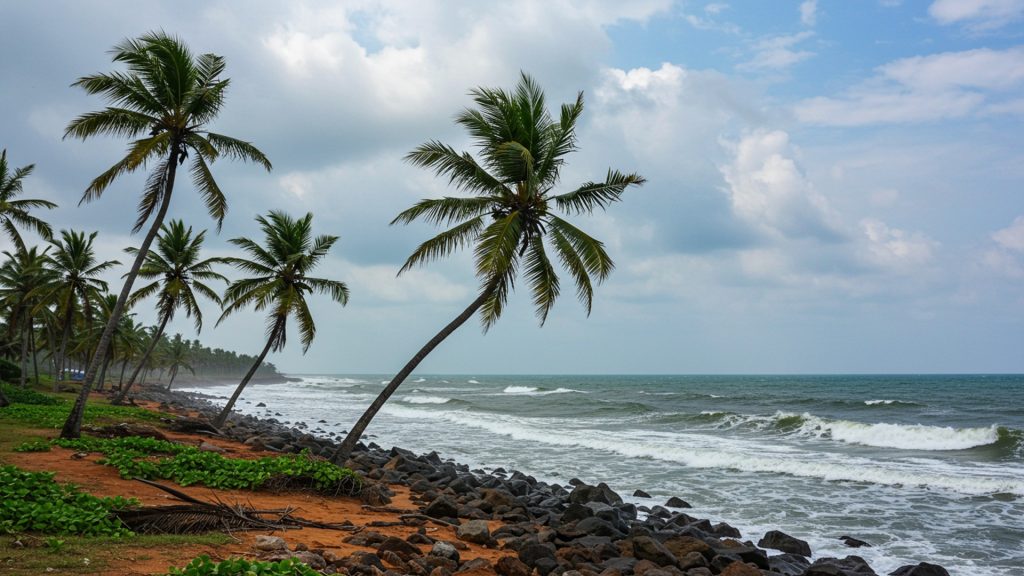
Coastal districts across Tamil Nadu are currently under a close watch as the India Meteorological Department (IMD) has issued a special alert regarding increased wind activity throughout August 2025. This advisory points to stronger surface winds that could affect daily life and various sectors along the state’s long coastline. The IMD reports that coastal areas are experiencing wind speeds between 35 and 45 kilometers per hour, with gusts occasionally reaching up to 55 kilometers per hour, particularly during the evening and night hours.
Districts like Nagapattinam, Chennai, Cuddalore. Thoothukudi are noted as facing these more intense conditions. Locals in these areas have already observed the stronger-than-usual sea breezes and increased dust being stirred up inland. Coastal roads, fishing harbors. port areas are all being carefully monitored to ensure public safety.
What the Wind Alert Means
The current wind alert from the IMD signifies a notable increase in wind speeds compared to the typical conditions for August. August is generally considered a transition month in Tamil Nadu’s weather calendar, moving between the southwest and northeast monsoon seasons. The stronger winds observed are mainly due to a mix of pressure differences over the Bay of Bengal and ongoing weather disturbances. These factors work together to boost the flow of surface winds towards the coast.
Recent forecasts indicate that strong surface winds, with speeds reaching 40 to 50 kilometers per hour, are very likely across South Peninsular India until August 19. There is also a low-pressure area that has developed over the west-central and nearby northwest Bay of Bengal, off the North Andhra Pradesh and South Odisha coasts. This system is expected to strengthen into a depression within 24 hours and move west-northwest, crossing the South Odisha and North Andhra Pradesh coasts around the morning of August 19, 2025.
For some areas, especially for fishermen, wind speeds could reach 45 to 55 kilometers per hour, with gusts potentially going up to 65 kilometers per hour. If a cyclonic system were to form, gusts could even reach 70 kilometers per hour. These speeds highlight the need for coastal communities to remain vigilant and take necessary safety steps.
Effects on People and Daily Activities
The stronger winds are expected to have a noticeable impact on various aspects of life in coastal Tamil Nadu. One of the most affected groups is the fishing community. Fishermen have been advised to exercise caution. While a full ban on fishing has not yet been put in place, it is recommended that small mechanized boats and country crafts avoid venturing into deep-sea areas, especially during the late evening hours. The sea conditions are likely to be rough, with choppy waves and unpredictable currents, making fishing dangerous. Previously, a strict ‘no-go’ warning for fishing was issued from August 13 to 18 for certain areas due to very rough sea conditions.
“Fishermen have been advised to stay cautious. While no full ban has been issued yet, small mechanised boats and country crafts are advised to avoid venturing into deep sea areas, especially during late evening hours. The sea state is likely to be rough with choppy waves and unpredictable currents.”
Beyond the sea, the gusty winds can also affect transport on land and in the air. Chennai Airport has already issued warnings to pilots about the risks of crosswinds during takeoffs and landings. On the roads, individuals riding two-wheelers in open coastal stretches need to be especially careful, particularly in the early mornings and late evenings when wind gusts are strongest. Such conditions can make driving difficult and increase the risk of accidents.
For homes and infrastructure, loose items can become dangerous projectiles. The Tamil Nadu Disaster Management Authority (TNDMA) has emphasized securing anything that could be blown away by strong winds. Power outages are also a possibility if high winds damage electric poles or lines.
Steps Taken by Government and Local Bodies
Authorities in Tamil Nadu are actively preparing for and responding to the wind alert to minimize potential harm. The Tamil Nadu Disaster Management Authority (TNDMA) has released a set of safety tips for residents living in the coastal belt. These tips are part of a broader effort to promote a culture of readiness, ensuring every household knows what to do before, during. after a severe weather event.
Coast guard units have been placed on standby in major ports, including Nagapattinam and Thoothukudi, to respond to any maritime emergencies. Government agencies are continuously watching the changing wind patterns and any signs of low-pressure systems forming, which could lead to more intense offshore activity.
The state government has also significantly improved its cyclone shelter network as part of its Cyclone Resilience Program. Tamil Nadu now operates over 350 cyclone shelters, strategically located in vulnerable coastal districts such as Nagapattinam, Cuddalore, Thoothukudi, Ramanathapuram. Chennai (especially fishing villages). These shelters are built to withstand very strong winds, up to 220 kilometers per hour. have elevated floors to protect against flooding. They are equipped with essential facilities like backup power systems, solar lighting, water purification units, first-aid rooms. separate areas for women, children. senior citizens. These shelters are designed to protect over 500,000 people during severe cyclones and also serve as community halls or schools during normal times.
| District | Average Wind Speed (km/h) | Gust Peaks (km/h) |
|---|---|---|
| Nagapattinam | 42 | 55 |
| Chennai | 38 | 50 |
| Cuddalore | 40 | 52 |
| Thoothukudi | 36 | 48 |
(Data based on recent IMD wind speed reports for August 2025)
In addition to physical infrastructure, the government conducts mock evacuation drills to prepare communities. Helpline number 1077 is active in all coastal districts for public assistance during emergencies.
Staying Safe for Residents
With the IMD’s August gust alert in effect, residents in coastal Tamil Nadu are strongly advised to take specific safety measures. Staying informed is key; people should regularly check updates from the IMD website or reliable weather apps.
-
Secure Loose Items: Check your property for any items that could be blown away by strong winds, such as roofing sheets, garden furniture, plant pots, or garbage bins. Secure them or bring them indoors.
-
Stay Indoors: During periods of high wind, especially during alerts, it is best to stay inside a sturdy building. Avoid unnecessary travel. If you live in vulnerable housing or very close to the sea, consider moving to a safer location if advised by authorities.
-
Driving Precautions: If you must drive, be extra cautious. Hold the steering wheel firmly with both hands and slow down. Be aware of sudden gusts that can push vehicles. Maintain a safe distance from high-sided vehicles like trucks and buses, as they are more affected by wind.
-
Avoid Dangerous Locations: Stay away from trees, electric poles. large billboards or scaffolding, as these can fall or collapse in strong winds. Never go near downed power lines, as they might still be live. Report them to local authorities.
-
Coastal Safety: When near the coast, be mindful of large waves, which can be unpredictable and sweep people off their feet, even from the shore. Avoid standing on piers, jetties, or harbor walls, as waves can knock you over instantly. Keep pets on a leash near cliffs and coastlines.
-
Emergency Kit: It is wise to have an emergency kit ready. This should include a battery-powered torch, a portable radio for news updates, a first aid kit, dry snacks, drinking water for at least two days, a backup phone charger, crucial documents stored in waterproof covers. a list of emergency contacts written down.
These simple steps can help residents protect themselves and their families during the period of stronger winds.
Past Weather Events and Lessons
Tamil Nadu has a history of facing various weather challenges, including strong winds and cyclones, especially during the monsoon transition months. The state’s long coastline makes it naturally exposed to these conditions. Historically, the peak of the Southwest Monsoon, which aligns with the Tamil month of ‘Aadi’ (roughly August-September), often brings the strongest surface winds to the region. This natural pattern often leads to increased wind energy generation in Tamil Nadu, which is a leading state in wind energy.
In recent years, Tamil Nadu has experienced several notable cyclonic events, such as Cyclones Nivar, Mandous. Michaung. For instance, Cyclone Michaung in December 2023 brought sustained winds of 110 kilometers per hour and caused widespread heavy rainfall and flooding in areas like Chennai, leading to significant disruption and evacuations. Such events highlight the importance of timely warnings and community preparedness. These past experiences have helped the state refine its disaster management plans and improve its infrastructure, such as building more resilient cyclone shelters and conducting regular safety drills, to better protect its residents.
![]()
